Seero Puts Videos on the Map

Tuesday, 13 May 2008

Seero

About Seero

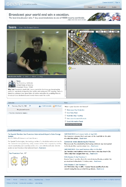
“Seero.com is a geo-broadcasting platform for users to broadcast and experience destinations around the world. Seero fuses live and on-demand video with GPS mapping to create a rich and unique user experience. Our goal is to shake the foundations of how you see video with a platform that promotes exploration and geographical awareness.

If you are looking for another typical video site, or ‘Television Online’, this probably isn’t the place for you. If you want to experience a new way to see the world, welcome. Seero utilizes the vast potential of the internet to create an original brand of content. If you are a citizen journalist, local tour guide, back road explorer, talented performer, or simply have a great destination to unveil, Seero is your platform to broadcast your world.”

See also

More: Where 2.0 News Coverage


“What does it mean to map everything all the time?”

Sunday, 2 March 2008

A feature “The New Cartographers: What does it mean to map everything all the time?” written by Jessica Clark and published by In These Times:

“Maps are everywhere these days. The ubiquity of global positioning systems (GPS) and mobile directional devices, interactive mapping tools and social networks is feeding a mapping boom. Amateur geographers are assigning coordinates to everything they can get their hands on — and many things they can’t. “Locative artists” are attaching virtual installations to specific locales, generating imaginary landscapes brought vividly to life in William Gibson’s latest novel, Spook Country. Indeed, proponents of “augmented reality” suggest that soon our current reality will be one of many “layers” of information available to us as we stroll down the street.”

The conclusion:

“In many ways, these mapping tools are re-locating us as the center of our personal universes. We no longer go to maps to find out where we are. Instead, we tell maps where we are and they form around us on the fly, a sensation that can be comforting or stifling. After all, while finding the right map can orient you, having dozens can threaten to tip the signal-to-noise ratio toward cacophony.

On balance, though, the democratization of mapping and visualization tools generates possibilities for self-expression and social action. Two decades ago, postmodern theorist Frederic Jameson argued that developing new maps would be central for activists hoping to grapple with the emerging global business and communication systems. ‘[The] incapacity to map socially is as crippling to political experience as the analogous incapacity to map spatially is for urban experience,’ he wrote.”

Via: http://www.alternet.org/mediaculture/78284/?page=entire


Wiesbaden 3D in Google Earth

Sunday, 10 February 2008

Wiesbaden 3D
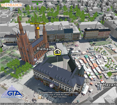
Since 18 january Wiesbaden presents a 3D view of the city in Google Earth – as the first city of Hesse, Germany. Wiesbaden follows Berlin, Hamburg, Dresden…www.wiesbaden.de/3d http://www.main-rheiner.de/region/objekt.php3?artikel_id=3128026


Google ad on “My Location”

Wednesday, 12 December 2007

This advertisement from Google via YouTube serves as a handsome explanation on what location-based services are and “The new ‘My Location’ (beta) feature on Google Maps for mobile helps you know where you are on the map, even if your phone doesn’t have GPS. Just press [0] to move the map to your approximate location. Save time and tedious keystrokes finding where you are, what’s around you, and how to get there.”

Via UBIKWITUS


“Ourstories” – children’s location-based experiences

Tuesday, 11 December 2007

Ourstories.org

Ourstories.org by Unicef, one laptop per child (OLPC) and Google is an oral history project, in which location is not only a set of longitude and latitude, but a social place in our world. The project is…

“a joint initiative to preserve and share the histories and identities of cultures around the world by making personal stories available online in many languages. Using laptops, mobile phones and other recording devices, children will record, in their native languages, the stories of elders, family members and friends. These stories will be shared globally through the Our Stories website, where they can be found on a Google Map.

By making these stories accessible around the world, the Our Stories project hopes to contribute to a better understanding of our shared humanity across countries and cultures, across religious traditions, across languages, and across generations.”

http://www.ourstories.org/ourpress/20071207_launch.html

Two examples on malaria, street kids and – music…

Press Release via Directions magazine.