“Using location-based technologies, Loopt lets you know where your friends are by automatically updating maps on your mobile handset. Loopt even lets you send messages to nearby friends or receive automatic alerts when they’re nearby so that you never miss an opportunity to meet. Loopt also lets you journal your life so that your friends can see what you’re up to. With Loopt, mobile subscribers put themselves on the map.”
“It is the first BlackBerry smartphone to support tri-band HSDPA high-speed networks around the world and comes with integrated GPS and Wi-Fi®, as well as a rich set of multimedia capabilities. From its lustrous black exterior, satin chrome finished frame and stylish leather-like backplate, to its stunning display, sophisticated user interface and newly designed full-QWERTY* keyboard, the BlackBerry Bold smartphone is a symbol of accomplishment and aspiration.” (Press Release #1)
“Research In Motion (RIM), RBC and Thomson Reuters, today announced plans to launch the BlackBerry Partners Fund, a US$150 million venture capital fund, to invest in mobile applications and services for the BlackBerry platform and other mobile platforms.”(Press Release #2)
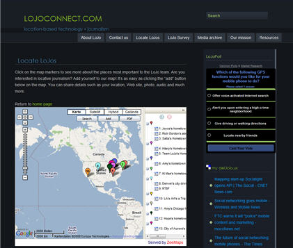
What is LoJo?
Shorthand for locative journalism, LoJo is the name of a project launched by a team of Northwestern University graduate students to study the intersection of journalism and emerging location-based technologies. Through this project, we hope to create interactive and informative mobile experiences that push innovation in journalism.
What is locative storytelling?
Using the bouquet of emerging mobile and location-based technologies (from GPS-enabled mobile phones to interactive online maps), locative storytelling provides multi-media content that enhances a user’s connection to a given place. At its best, this kind of interactive media gives users increased entry points, and more control over, any given story, thereby enabling deeper and more vibrant experiences.
What are some examples?
If you’ve ever been on an audio tour of a museum or a city neighborhood, you’ve experienced locative storytelling. Other examples include Google mash-ups (user-enhanced Google maps that layer location-specific information over area maps) and GPS-based mobile games.
JotYou™ is location based messaging. Send a message to your friends so they get it when they arrive at school or the ballpark or the mall. Make up geo-games. Track a foot race or bicycle race. Stage a road rally with virtual checkpoints, and feed the directions as participants progress. Ever plan to pick up the milk on the way home from work, but drive right by the store and forget? Use JotYou™ to remind yourself as you pass by specified locations. The possibilities are endless.
How it works: You send a message to one person or many people, and specify a delivery time and location using the map on the computer, or an address from your mobile. When they arrive at the location you specify, JotYou™ alerts them by “buzzing” their cell phone, and delivering the message. It’s just that simple!
“The GPS modernization project and the arrival of additional Global Navigation Satellite Systems (GNSS) such as GLONASS, Galileo, and Beidou/Compass will increase the availability, reliability, and precision of satellite positioning and stimulate the location ecosystem, expanding the market to more than 900 million units by 2013.
‘Personal Navigation Devices for in-car use will be increasingly complemented by converged solutions based on GPS-enabled handsets for pedestrian navigation and Location Based Services,’ says ABI Research principal analyst Dominique Bonte. ‘However, GNSS technologies will have to be combined with other positioning solutions such as A-GPS, Wi-Fi, and dead reckoning to address the indoor coverage issue. Dedicated GPS devices will remain the preferred option for specific applications and environments such as outdoors, marine, recreational aviation, and tracking of people and animals.
(…)
Advances in GPS chipset development will enable the integration of GPS technology in all mobile devices at low cost by 2013. This will drive new applications such as the automatic geo-tagging of pictures taken with digital cameras. Other innovative applications include road toll systems and tourism. Mobile location-based social networking features will be an important driver for the uptake of GPS devices and applications in the consumer market.”
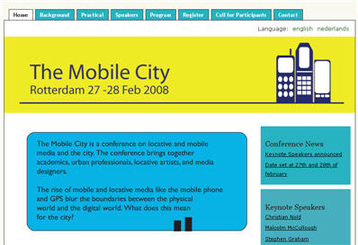
“The Mobile City is a conference on locative and mobile media and the city. The conference brings together academics, urban professionals, locative artists, and media designers.
The rise of mobile and locative media like the mobile phone and GPS blur the boundaries between the physical world and the digital world. What does this mean for the city?”
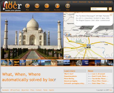
Germany-based company locr states that their software for Symbian S60 phones is available at Nokia’s EMEA download site – in a press release for instance via inar.de. locr offers a community and a software for geotagging photos.
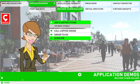
GeoVector® Corporation, the leading provider of “advanced search” capabilities for location-based applications, today announced an additional patent within its augmented reality technology family.
US Patent 7301536better enables mobile phones or other devices to display stored digital images which are linked to real-world objects or places.
“Imagine pointing a mobile device down a city street and seeing a digital image of how that street looked a century ago, or might look a century from now. Imagine pointing at a new car billboard and seeing the car in any color you want, then downloading a video clip,” explained John Ellenby, GeoVector’s CEO. “GeoVector’s technology enables countless possibilities for entertainment, advertising or e-commerce applications.”
GeoVector currently enables mobile devices to access data on points of interest using a unique combination of GPS and a built-in compass. The new patent builds upon that capability, allowing users to interact with stored images based on their surroundings.
The company currently provides products and services which significantly simplify local searches, allowing users to point their mobile device toward objects of interest to access information about them. Users can “point and click” with their mobile phone the way a computer user navigates using a mouse.
“With the real world as your desktop, the possibilities are endless,” Ellenby said. (…)
A demo video by GeoVector via YouTube.
[Please send press releases to editors (at )voss-publishing( dot) net]
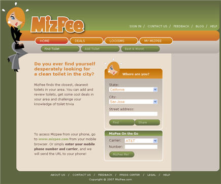
About: “MizPee finds the closest, cleanest toilets in your area. You can add and review toilets, get some cool deals in your area and challenge your knowledge of toilet trivia”.
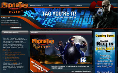
“PhoneTag Elite [KnowledgeWhere, Calgary, Alberta, Canada] turns hide and seek into a radical group sport across North America by using the mobile phone as a console for chatting and location-tracking. Available exclusively to Sprint customers across America, taggers can shop in-game at their favourite brand stores for tools to help evade capture and pursue targets.
PhoneTag Elite is designed to build both team and community relationships, encourage physical and mental agility, and introduce a new way of playing interactive games from your mobile phone. But, most of all, PhoneTag Elite is designed to be fun. PhoneTag Elite utilizes a patent pending, proprietary technology that protects individuals’ privacy and ensures the players true location is never revealed.”
“Anna’s Secret [by Jan Ulrich Schmidt, Hamburg, Germany] is a GPS driven, location-based learning adventure game for cultural content in the city of Weimar (Germany). A player walks with a GPS-able Pocket PC through the Ilm-park and passes sightseeings. Video clips show Anna and explain the sights, which have an important role in the game. On his way the player has to solve different quests and mysteries to solve Anna’s Secret. If he does well, he can find a treasure chest.
The story of a ghost that suffers from amnesia is used to immerse the player into the gameplay. Many videos show the ghost Anna or details of the park and its history. The game could be adapted to any other city, if the content and the story are modified.
Anna’s Secret is based on the game ‘geocaching’, but extends this play by video and film clips, multimedia features, components of a adventure game and a real, historical background story.
Over The Air – The InformationWeek’s Mobile Weblog presents an interview with Sal Dhanani, co-founder and senior director of marketing at TeleNav, who expects 2008 to be a growth year for LBS applications.
One of the questions by Stephen Wellmann was “What new business apps will we see in 2008 that utilize location?”
Sal’s answer: “So far LBS business apps have been horizontal, meaning one size fits all. In 2008 we’ll see the beginnings of tailored LBS apps for verticals and also highly customized apps for enterprise accounts.”
This advertisement from Google via YouTube serves as a handsome explanation on what location-based services are and “The new ‘My Location’ (beta) feature on Google Maps for mobile helps you know where you are on the map, even if your phone doesn’t have GPS. Just press [0] to move the map to your approximate location. Save time and tedious keystrokes finding where you are, what’s around you, and how to get there.”
“In the work the listener is asked to locate various substances that form the contemporary urban environment (glass, stone, concrete etc.). As they mark the location of each one they begin to hear interwoven stories connecting them to remote locations around the world, soundtracked with a generative music score. The narratives are progressed and concluded as the listener returns to the locations they chose. The piece is reflective and sometimes melancholy, it touches on issues of climate change and global awareness, but ultimately encourages the listener to treasure the moments around them…”
1. This one shows the nodeexplorer as the “Stourhead GPS Explorer”
2. Here is an example of a program for the nodeexplorer as “Stourhead GPS Explorer”. I like it, as it does not simply show the reality, but reconstructs the past.
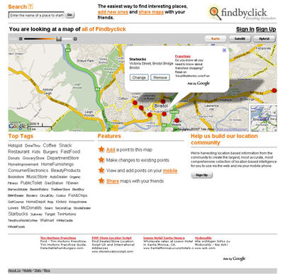
“We’re harvesting location based information from the community to create the largest, most accurate, most comprehensive collection of location based intelligence for you to use via the web and via your mobile phone.”
“We want to build a community of people interested in sharing location-based information for the mutual benefit of all. For others, it is a way to share memorable places: a great place to eat, a hot vacation destination, or a special place to watch the sunset. FindbyClick is a place where you get to tell the story.”

“Using location-based technologies, Loopt lets you know where your friends are by automatically updating maps on your mobile handset. Loopt even lets you send messages to nearby friends or receive automatic alerts when they’re nearby so that you never miss an opportunity to meet. Loopt also lets you journal your life so that your friends can see what you’re up to. With Loopt, mobile subscribers put themselves on the map.”


 Posted by Andreas H. Bock
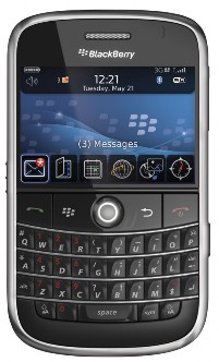


You must be logged in to post a comment.