Locative Journalism

Sunday, 11 May 2008

LoJo

What is LoJo?
Shorthand for locative journalism, LoJo is the name of a project launched by a team of Northwestern University graduate students to study the intersection of journalism and emerging location-based technologies. Through this project, we hope to create interactive and informative mobile experiences that push innovation in journalism.


What is locative storytelling?

Using the bouquet of emerging mobile and location-based technologies (from GPS-enabled mobile phones to interactive online maps), locative storytelling provides multi-media content that enhances a user’s connection to a given place. At its best, this kind of interactive media gives users increased entry points, and more control over, any given story, thereby enabling deeper and more vibrant experiences.


What are some examples?

If you’ve ever been on an audio tour of a museum or a city neighborhood, you’ve experienced locative storytelling. Other examples include Google mash-ups (user-enhanced Google maps that layer location-specific information over area maps) and GPS-based mobile games.

http://lojoconnect.com/about-lojo/


Southampton’s Hidden Histories – Locative FM

Saturday, 29 March 2008

2008-03-29_hidden-histories-southampton_small.jpg

Hidden Histories of Southampton” is a oral history project using sort of a “Locative FM”. The project was launched on 14 March 2008. The press release:

Discover Southampton’s Hidden Histories

Southampton’s fascinating history is to be uncovered for all to hear as the revolutionary new concept of Street Radio comes to the city.

A unique street radio system, will be used across an exciting new heritage trail called Hidden Histories, which will be launched in Central Southampton on March 14 in the run up to Southampton ShowsOff, which is running throughout the weekend to show case Southampton’s creativity, talent and culture.

Street Radio is a new way of experiencing the city. The system utilises wireless communication technologies such as WIFI and Bluetooth in combination with FM radio to create captive ‘puddles’ where particular stories and themes can be heard.

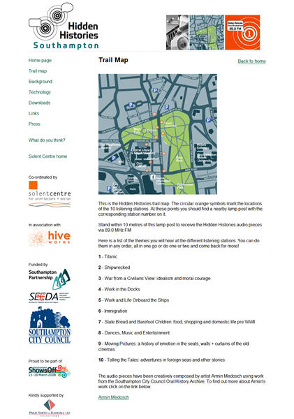
By broadcasting using very weak radio transmitters a selection of stories from the Oral History Unit can be heard along 10 nodal points in the city where byte-sized stories are transmitted. These nodes link together to form a media rich walk that transports people through the changing life of the city.

“Hidden Histories makes accessible some of the highs and lows of Southampton’s 20th Century history, the glory of great ships and journeys as well as the disasters and long forgotten tales,” said Arts and Heritage Manager, Janet Owen.

The walk begins in and around the proposed ‘Cultural Quarter’ on Above Bar Street and the Civic Centre complex. And you can experience the walk 24 hours a day, seven days a week through any FM radio receiver or Bluetooth enabled mobile phone.

Route maps and radio units can be hired from Southampton’s Tourist Information Centre and more information can be found at http://www.hiddenhistories.org.uk

Cabinet member for Leisure and Neighbourhoods, Councillor Derek Burke, said: “This is a fantastic opportunity for people to enjoy Southampton’s history in a completely new and stimulating way using the latest technology.”

The Solent Centre for Architecture + Design, in partnership with London based media art innovators Hive Networks and artist Armin Medosch, have been working with Southampton City Council’s Oral History Unit on this unique project.”

http://www.hiddenhistories.org.uk/?id=hiddenhistoriespress


“What does it mean to map everything all the time?”

Sunday, 2 March 2008

A feature “The New Cartographers: What does it mean to map everything all the time?” written by Jessica Clark and published by In These Times:

“Maps are everywhere these days. The ubiquity of global positioning systems (GPS) and mobile directional devices, interactive mapping tools and social networks is feeding a mapping boom. Amateur geographers are assigning coordinates to everything they can get their hands on — and many things they can’t. “Locative artists” are attaching virtual installations to specific locales, generating imaginary landscapes brought vividly to life in William Gibson’s latest novel, Spook Country. Indeed, proponents of “augmented reality” suggest that soon our current reality will be one of many “layers” of information available to us as we stroll down the street.”

The conclusion:

“In many ways, these mapping tools are re-locating us as the center of our personal universes. We no longer go to maps to find out where we are. Instead, we tell maps where we are and they form around us on the fly, a sensation that can be comforting or stifling. After all, while finding the right map can orient you, having dozens can threaten to tip the signal-to-noise ratio toward cacophony.

On balance, though, the democratization of mapping and visualization tools generates possibilities for self-expression and social action. Two decades ago, postmodern theorist Frederic Jameson argued that developing new maps would be central for activists hoping to grapple with the emerging global business and communication systems. ‘[The] incapacity to map socially is as crippling to political experience as the analogous incapacity to map spatially is for urban experience,’ he wrote.”

Via: http://www.alternet.org/mediaculture/78284/?page=entire


GPS Drawings: “Message in a Bottle” (2004ff.)

Wednesday, 9 January 2008

Layla Curtis - Message in a bottle

About the project:

“On 25th May 2004, fifty bottles containing messages were released into the sea off the south-east coast of England near Ramsgate Maritime Museum, Kent. The intended destination of the bottles is The Chatham Islands in the South Pacific Ocean. The islands, which are 800km east of mainland New Zealand, are the nearest inhabited land to the precise location on the opposite side of the world to Ramsgate Maritime Museum. It is anticipated that the bottles may be found several times before reaching the Chatham Islands.

Several of the bottles are being tracked using GPS technology and are programmed to send their longitude and latitude coordinates back to Ramsgate every hour. The information they transmit is used to create a real time drawing of their progress.”

http://www.laylacurtis.com/bottle/home.htm
Via Pasta&Vinegar


“The Mobile City” conference 2008 at Rotterdam

Thursday, 20 December 2007

The Mobile City

“The Mobile City is a conference on locative and mobile media and the city. The conference brings together academics, urban professionals, locative artists, and media designers.

The rise of mobile and locative media like the mobile phone and GPS blur the boundaries between the physical world and the digital world. What does this mean for the city?”

Rotterdam, 27-28 February 2008

http://www.themobilecity.nl/