For the colleagues, friends and marketing guys out there who didn’t notice it. Sorry, I am busy at the moment. No editing or publishing until further notice…
GoCars go Europe
Monday, 21 July 2008GoCarsTours went to Barcelona, Spain, and Lisboa, Portugal.
“San Francisco (ots/PRNewswire) – GoCar, der im April 2004 in San Francisco gegründete Anbieter origineller, GPS-geführter Stadtrundfahrten, hat den grossen Sprung vom US-amerikanischen Markt nach Europa geschafft und Niederlassungen in Barcelona und Lissabon eröffnet. Mit den neuen Niederlassungen in der EU verfügt GoCar neben San Francisco, San Diego und Miami nun über insgesamt 5 Standorte weltweit.”
http://www.presseportal.de/pm/72016/1227152/gocar_tours (2008-07-11)
 Leave a Comment » |
  News, Services, Videos | Tagged: Barcelona, city guide, GoCar, GoCars, GPS, Lisboa, Lissabon, Portugal, Spain, Spanien, tours, Videos |
  Permalink
 Posted by Andreas H. Bock
Evaluating Player Experiences in Location-Aware Games
Monday, 21 July 2008Workshop “Evaluation Player Experiences in Location Aware Games”
Where? HCI 2008: Culture, Creativity, Interaction
When? 1-5 Sept. 2008, Liverpool, John Moores University, UK
http://www.hci2008.org
“Location aware technologies such as widespread mobile computers and varying location sensors open up a massive range of possibilities for extending game playing into streets, buildings and even the rural landscape. New and extended forms of location-aware games including mobile or pervasive phone games, smart toys, role-playing games as well as Mixed Reality (MR) games all demonstrate promising new forms of game play. Substantial work has also gone into new game concepts, sophisticated technology and viable business models. However, research on the methodological issues of studying mobile player experiences, pervasive game activity and ubiquitous interaction has become necessary.
Furthermore, there is also a need to explore the methodological issues in the evaluation of the intertwined, mutually dependent dimensions related to the usability and playability of location-based games.
This workshop will bring together researchers, practitioners, and students with the objective of sharing knowledge, experience and ideas so that the many user experience issues of location aware games can be more thoroughly addressed.”
Source: Locative Digest, Vol 24, Issue 2 http://locative.x-i.net
Leave a Comment » | Events, News | Tagged: evaluation, game play, iPhone, location-aware games, Location-based Game, methodology, Mobile Computing, mobile games, mobile player experience, playability, research, usability | Permalink
Posted by Andreas H. Bock
“Landvermesser.tv” is Map-based Storytelling
Monday, 21 July 2008n-tv berichtet über eine Kulturprojekt, das im Juli 2008 in Berlin startet:
„Wir haben uns alle mit Literatur, Websites und Geotags beschäftigt und wollten das verschmelzen“, erklärt Tatjana Brode, die neben Jens Krisinger und Mathias Ott zu den Initiatoren des Projektes gehört. Kartenbasiertes Erzählen bedeute bislang meist, zweckorientierte oder historische Informationen zu verorten, so Brode weiter. „Uns war es wichtig, die Eindrücke der Stadt um eine fiktionale Komponente zu erweitern und ihnen eine literarische Bedeutung zu geben. Deshalb haben wir auf den Spaziergängen versucht, den Autoren ihre Geschichten zu entlocken und die Stadt als Buch zu öffnen.“
Leave a Comment » | Events, News, Projects | Tagged: Berlin, city, Cruso, culture, GPS, literature, storytelling, video, walks | Permalink
Posted by Andreas H. Bock
iPhone 3G with GPS
Monday, 21 July 2008
 “SAN FRANCISCO—June 9, 2008—Apple® today introduced the new iPhone™ 3G, combining all the revolutionary features of iPhone with 3G networking that is twice as fast* as the first generation iPhone, built-in GPS for expanded location based mobile services…” [launched July 11, 2008]
http://www.apple.com/pr/library/2008/06/09iphone.html
Pictures: Apple
Leave a Comment » | News, Products, Special: GPS phones | Tagged: A-GPS, applications, apps, GPS, iPhone, location-based services, mobile phone | Permalink
Posted by Andreas H. Bock
Ushahidi maps violence in Kenya
Thursday, 15 May 2008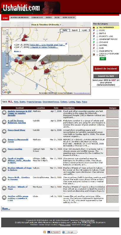
Ushahidi.com is a tool for people who witness acts of violence in Kenya in these post-election times. You can report the incident that you have seen, and it will appear on a map-based view for others to see. We are working with local Kenyan NGO’s to get information and to verify each incident.
What you can do is get the word out about Ushahidi so that it’s utilized to it’s full potential. This especially extends to talking to the people that you know who have seen things in Kenya and getting them to the site as well. You can also help by using the contact form to volunteer to help with the tracking and verifying of each incident.”
http://www.ushahidi.com/about.asp
Erik Hersman presented the project at Where 2.0
Leave a Comment » | News, Projects, Services, Special: Where 2.0 | Tagged: activist, Africa, elections, Google mashup, Kenya, map, NGO, Where 2.0 | Permalink
Posted by Andreas H. Bock
Seero Puts Videos on the Map
Tuesday, 13 May 2008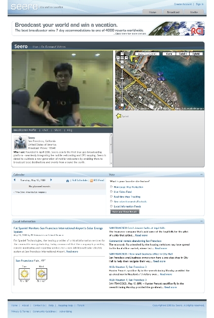
“Seero.com is a geo-broadcasting platform for users to broadcast and experience destinations around the world. Seero fuses live and on-demand video with GPS mapping to create a rich and unique user experience. Our goal is to shake the foundations of how you see video with a platform that promotes exploration and geographical awareness.
If you are looking for another typical video site, or ‘Television Online’, this probably isn’t the place for you. If you want to experience a new way to see the world, welcome. Seero utilizes the vast potential of the internet to create an original brand of content. If you are a citizen journalist, local tour guide, back road explorer, talented performer, or simply have a great destination to unveil, Seero is your platform to broadcast your world.”
See also
More: Where 2.0 News Coverage
Leave a Comment » | News, Services, Special: Where 2.0 | Tagged: Google, map, Mashup, Seero, video, Where 2.0 | Permalink
Posted by Andreas H. Bock
BlackBerry Bold FKA 9000
Monday, 12 May 2008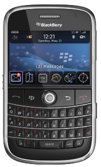
“It is the first BlackBerry smartphone to support tri-band HSDPA high-speed networks around the world and comes with integrated GPS and Wi-Fi®, as well as a rich set of multimedia capabilities. From its lustrous black exterior, satin chrome finished frame and stylish leather-like backplate, to its stunning display, sophisticated user interface and newly designed full-QWERTY* keyboard, the BlackBerry Bold smartphone is a symbol of accomplishment and aspiration.” (Press Release #1)
“Research In Motion (RIM), RBC and Thomson Reuters, today announced plans to launch the BlackBerry Partners Fund, a US$150 million venture capital fund, to invest in mobile applications and services for the BlackBerry platform and other mobile platforms.” (Press Release #2)
(Photo: RIM)
Leave a Comment » | News, Products, Special: GPS phones | Tagged: Blackberry, Bold, GPS, LBS, location-based services, mobile, phone, RIM, Services | Permalink
Posted by Andreas H. Bock
Locative Journalism
Sunday, 11 May 2008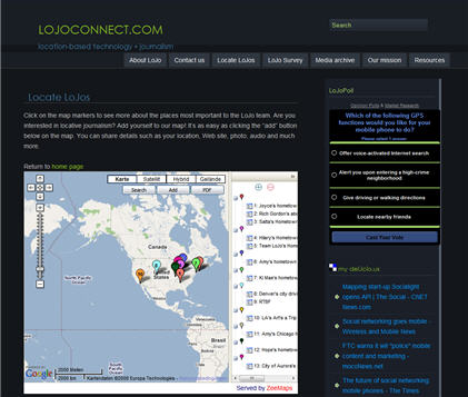
What is LoJo?
Shorthand for locative journalism, LoJo is the name of a project launched by a team of Northwestern University graduate students to study the intersection of journalism and emerging location-based technologies. Through this project, we hope to create interactive and informative mobile experiences that push innovation in journalism.
What is locative storytelling?Using the bouquet of emerging mobile and location-based technologies (from GPS-enabled mobile phones to interactive online maps), locative storytelling provides multi-media content that enhances a user’s connection to a given place. At its best, this kind of interactive media gives users increased entry points, and more control over, any given story, thereby enabling deeper and more vibrant experiences.
What are some examples?If you’ve ever been on an audio tour of a museum or a city neighborhood, you’ve experienced locative storytelling. Other examples include Google mash-ups (user-enhanced Google maps that layer location-specific information over area maps) and GPS-based mobile games.
Leave a Comment » | Definitions, News, Projects | Tagged: experience, GPS, innovation, journalism, LBS, location-based journalism, location-based technologies, locative, locative journalism, LoJo, mobile, storytelling | Permalink
Posted by Andreas H. Bock
Antenna Audio and Citysearch are barcoding San Francisco with Scanbuy
Sunday, 30 March 2008 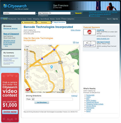
Scanbuy’s Technology Turns Camera Phones into Barcode Scanners – Connecting People to Local Information On-the-Go for the First Time in US
New York – March 26, 2008 – Citysearch, a leading online local information guide and an operating business of IAC (Nasdaq: IACI), and Antenna Audio, a global leader in audio interpretation, announced separately today that they will deploy Scanbuy’s advanced barcode technology giving mobile phone users instant access to a wide range of local information when and where they need it most. Today’s launch marks the first time Scanbuy’s technology has been used to deliver local, mobile content in the United States.
By using ScanLife technology from Scanbuy, a global leader in mobile marketing solutions that turns camera phones into barcode scanners, Citysearch will link San Francisco users to local content on various restaurants, businesses and leading services while Antenna Audio will provide instant information about local historical landmarks.
More than 500 restaurants and businesses in San Francisco will display ScanLife 2D barcodes, called EZcodes, which deliver Citysearch’s original and consumer-generated reviews directly to a user’s phone, allowing immediate access to relevant information and eliminating the extra steps of typing lengthy website addresses into mobile browsers.
“People visit Citysearch.com daily for information about places to go in their city and now with ScanLife EZcodes, they can review information exactly when they need it most – at a local business’s front door,” said Rob Angel, Vice President, Media & Advertising, Citysearch. “EZcodes give locals and visitors the power of the Internet without having to search through information they don’t need. It fundamentally changes the user experience because it allows instant, up-to-the-minute access to the reviews and recommendations most relevant to the user at that moment.”
Audio tour provider Antenna Audio, acquired by Discovery Communications, Inc. in 2006, is using ScanLife to provide audio clips of local San Francisco landmarks right to an individuals’ mobile phone. This content has historically required hardware rental from locations like museums and galleries.
“In partnering with Scanbuy, Antenna Audio is hoping to drive users of mobile devices to access destination relevant content using ScanLife 2D technology as they explore the city”, said Sarah Dines, Managing Director of Antenna Audio for the Americas. “Our goal is to provide a first-rate audio experience for every user, and this mobile technology is a fantastic way to bring tours to as many people throughout San Francisco as possible.”
ScanLife technology uses camera phones to connect the physical world to the digital world. Businesses and content providers can use EZcodes to extend brand engagement onto mobile devices. At the same time, it affords mobile phone users the luxury of getting the most up-to-date information quickly and easily at the time they are actively making decisions or looking for answers.
All EZcodes can be accessed by users with compatible phones after downloading the free ScanLife software though the mobile browser at http://www.getscanlife.com, or by texting SCAN to 70734. Because of their simple design, EZcodes are supported by over 65 different camera phone models from all major US wireless carriers. The ScanLife Code Registry and Management platform has been deployed in France, Spain, the Philippines, Brazil and the United States.
“We are thrilled to have the potential of ScanLife fully realized by both Citysearch and Discovery Communications in this project,” said Jonathan Bulkeley, Chief Executive Officer of Scanbuy. “These partners are a natural fit, as they provide the most up-to-date and in-depth local information. This is a great opportunity to provide individuals throughout San Francisco instant access to a wealth of information from Citysearch about their favorite places and inside information about historical landmarks from the leader in audio tours, Discovery Communications.”
About Antenna Audio For more over 20 years, Antenna Audio has been the leading provider of audio and audio-visual interpretation to museums, exhibitions, historic sites and visitor attractions around the world. Today, we distribute more than 20 million tours every year and have a network of 16 offices around Europe, North America and Asia, currently employing around 350 full time staff. Acquired in April 2006 by Discovery Communications, Inc., Antenna Audio is now part of the leading real-world media brand on all platforms. Discovery Communications is the number-one nonfiction media company reaching more than 1.5 billion cumulative subscribers in over 170 countries. For more information about Antenna Audio, please visit http://www.antennaaudio.com.
About Citysearch Citysearch is a leading local search and directory company that provides the most up-to-date information on businesses, from restaurants and retail, to travel and professional services. Citysearch empowers consumers to make informed decisions about where to spend their time and money by delivering trusted content, local expertise and helpful tools, including over 18 million local business listings and over 1.5 million user reviews nationwide. Citysearch is an operating business of IAC (NASDAQ: IACI). For more information, visit: http://www.citysearch.com
About Scanbuy, Inc. Scanbuy is the leading global provider of mobile marketing solutions that use the camera phone as the link between the physical world and the digital world. Scanbuy’s 2D barcode capture technology is revolutionizing the way media companies, marketers, handset manufacturers and carriers around the world provide information and services to consumers on their mobile phones. Founded in 2000, Scanbuy has a strong and growing intellectual property base in 2D barcode technology. The company’s investors include Longworth Venture Partners, Masthead Venture Partners and Hudson Ventures. For more information about Scanbuy solutions, please visit http://www.scanbuy.com or http://www.scanlife.com.
Leave a Comment » | News, Products, Projects, Services | Tagged: Antenna Audio, Barcode, barcode scanner, camera, Camera Phones, Citysearch, Phones, San Francisco, Scanbuy, Scanlife | Permalink
Posted by Andreas H. Bock
Southampton’s Hidden Histories – Locative FM
Saturday, 29 March 2008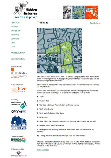
“Hidden Histories of Southampton” is a oral history project using sort of a “Locative FM”. The project was launched on 14 March 2008. The press release:
Discover Southampton’s Hidden Histories
Southampton’s fascinating history is to be uncovered for all to hear as the revolutionary new concept of Street Radio comes to the city.
A unique street radio system, will be used across an exciting new heritage trail called Hidden Histories, which will be launched in Central Southampton on March 14 in the run up to Southampton ShowsOff, which is running throughout the weekend to show case Southampton’s creativity, talent and culture.
Street Radio is a new way of experiencing the city. The system utilises wireless communication technologies such as WIFI and Bluetooth in combination with FM radio to create captive ‘puddles’ where particular stories and themes can be heard.
By broadcasting using very weak radio transmitters a selection of stories from the Oral History Unit can be heard along 10 nodal points in the city where byte-sized stories are transmitted. These nodes link together to form a media rich walk that transports people through the changing life of the city.
“Hidden Histories makes accessible some of the highs and lows of Southampton’s 20th Century history, the glory of great ships and journeys as well as the disasters and long forgotten tales,” said Arts and Heritage Manager, Janet Owen.
The walk begins in and around the proposed ‘Cultural Quarter’ on Above Bar Street and the Civic Centre complex. And you can experience the walk 24 hours a day, seven days a week through any FM radio receiver or Bluetooth enabled mobile phone.
Route maps and radio units can be hired from Southampton’s Tourist Information Centre and more information can be found at http://www.hiddenhistories.org.uk
Cabinet member for Leisure and Neighbourhoods, Councillor Derek Burke, said: “This is a fantastic opportunity for people to enjoy Southampton’s history in a completely new and stimulating way using the latest technology.”
The Solent Centre for Architecture + Design, in partnership with London based media art innovators Hive Networks and artist Armin Medosch, have been working with Southampton City Council’s Oral History Unit on this unique project.”
1 Comment | News, Projects | Tagged: Armin Medosch, arts, FM, Hidden Histories, history, locative, oral history, radio, Southampton, UK | Permalink
Posted by Andreas H. Bock
Geopedia = iPhone + Locative Wikipedia
Wednesday, 26 March 2008 iPhoneFAQ about the release of a third party software for the iPhone on 19 March: “GeoPedia takes advantage of geographic positioning functionality, like those introduced in iPhone firmware 1.1.3, and provides iPhone owners with a Wikipedia feed customized to their current location.”
“The usefulness of GeoPedia to traveling iPhone owners (which we all are, in a sense) is easy to imagine. Have some time to kill after a business meeting in an unfamiliar city? Let GeoPedia and Wikipedia provide some fodder that might lead to some interesting excursions. Exactly how well GeoPedia works is yet to be seen, but the idea is a good one, and so far users are reporting some pretty impressive results.”
Source and picture: http://www.iphonefaq.org/archives/97405
Via Slashgeo and Wikipedia Blog
Leave a Comment » | News, Services | Tagged: application, Geopedia, iPhone, location based service, Wikipedia | Permalink
Posted by Andreas H. Bock
Guides for Handicapped People
Tuesday, 25 March 2008CSD Partners With BarZ Adventures to Give Virtual Sign Language Tours of Austin
Bar Z Adventures has created a a tour available completely in American Sign Language (ASL) together with CSD (Communication Service for the Deaf, Inc.):
“With Austin’s reputation as a hub for innovation and technology, we’re proud to offer the cutting-edge GPS Ranger tour. The tour lends itself nicely to both leisure and business travelers, as visitors can explore the city at their own pace, on their own or with a group, stopping to learn more about the sites that pique their specific interests,” says Bob Lander, president and chief executive officer of Austin CVB [Austin Convention & Visitors Bureau]. “We are especially excited to offer the American Sign Language tour, which increases accessibility and helps us provide the best services and amenities possible for all visitors. The GPS Ranger allows deaf or hard of hearing visitors to experience Austin with the assistance of a personal guide who details the city’s rich history and signature attractions in American Sign Language.”
Soundcom und Transformat präsentieren eine GPS-gesteuerte Touristenführung für Blinde auf der Hallig Hooge
(GPS Guide for Blind Visitors of the North Sea Holm “Hooge”, Germany)
Hallig Hooge gilt als die Königin unter den zehn weltweit einzigartigen Halligen im Schleswig-Holsteinischen Wattenmeer. Dank des neuen elektronischen Touristenführers bleiben ihre Attraktionen nun auch den blinden und sehbehinderten Touristen nicht mehr verborgen. Mithilfe des satellitengestützten Positionierungssystems GPS (Global Positioning System) wird der Standort der Besucher wie mit einem Navigationsgerät im Auto erkannt, und die passenden Audio-Beschreibungen starten automatisch. Zu hören sind spezielle Texte für Blinde und Sehbehinderte, die das Beschreiberteam Nord im Hörfilm e.V. gemeinsam mit der Gästeführerin Dr. Renée Oetting-Jessel entwickelt hat und die von den Hamburger Sprechern und Schauspielern Bettina Radener und Michael Bideller im Studio der Soundcom GmbH eingesprochen wurden.
Leave a Comment » | News, Services | Tagged: Austin, barrierefrei, BarZ Adventures, Blinde, GPS, Guides, Hallig Hooge, handicapped, Holm, Ranger, Taube, Texas | Permalink
Posted by Andreas H. Bock
AntennaAudio: Walk the Wall!
Monday, 24 March 2008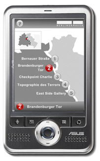
In May 2008 Antenna Audio starts the first gps guide on the history of the Berlin Wall (German/English). The “MultiMediaGuide” for pedestrians and cyclists consists of interviews, historic audio takes and video footage.
(Picture: Antenna Audio)
Leave a Comment » | News, Services | Tagged: Antenna Audio, Berlin, GPS, Guide, mutl-media, pedestrian, Tour, tourism, Walk the Wall | Permalink
Posted by Andreas H. Bock
Locative Mobile Phone Game “Parallel Kingdom”
Sunday, 23 March 2008 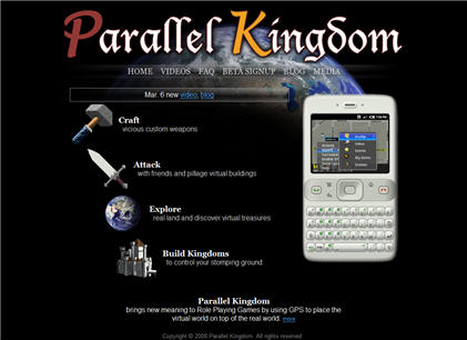
This is a Locative Mobile Phone Game (LMPG). A game for iPhone and Android, which uses either GPS or the My Location feature of Google Maps on the iPhone:
“According to its description, Parallel Kingdom places the virtual world on top of the real world using the GPS inside your phone. You can attack, dance, hug or team up with anyone around you. Set up trade routes, craft items or even create your own kingdom.
You can mine resources, build buildings, craft items, trade goods, meet people, start kingdoms, lead wars, and explore the world. Wherever you are, you can open your phone and play, whether you’re on the bus, walking down the street, or at home. Anywhere in the world, any time of the day. Parallel Kingdom never stops, you play it when you want and where you are.”
Source: iPhone World
Pocketgamer.co.uk published an interview with the CEO of Parallel Kingdom, Justin Beck:
Pocketgamer: How do the GPS aspects work? How are you tackling the problem that people might not be within range of anyone else who owns the game?
Justin Beck: We want to find some balance between leveraging the location game play of Parallel Kingdom without forcing players to move to do every little thing, which could get annoying quickly.
The GPS controls what part of a neighbourhood you are in and from that location you can then move your character within a couple block radius of your actual location. Giving you the freedom to explore while still being completely location based.”
From: Google Android and iPhone get their first MMORPG
Videos by Parallel Kingdom:
2 Comments | News, People, Products, Videos | Tagged: Android, Google maps, GPS, iPhone, Locative Game, MMORPG, My Location, Parallel Kingdom, RPG | Permalink
Posted by Andreas H. Bock
GPS city game at Jena
Sunday, 9 March 2008The Berlin-based company tranformat recently announced the production of a gps urban game for the city Jena, Thuringia, Germany.
“31.01.2008
Jena bekommt “Schnapphans” – ein GPS-Stadtspiel
Ab Sommer ’08 können sich die Jenaer ebenso wie die Besucher der Stadt mit einem Leih-PDA auf eine interaktive Entdeckungstour durch Jena begeben. Die technische Umsetzung des anspruchsvollen Spielkonzepts von art+wege aus Weimar übernimmt transformat.”
Leave a Comment » | News, Projects, Services | Tagged: art+wege, Germany, GPS, Jena, location-based media, pda, pervasive games, rental, Thuringen, Thuringia, urban games, Weimar | Permalink
Posted by Andreas H. Bock


You must be logged in to post a comment.