n-tv berichtet über eine Kulturprojekt, das im Juli 2008 in Berlin startet:
„Wir haben uns alle mit Literatur, Websites und Geotags beschäftigt und wollten das verschmelzen“, erklärt Tatjana Brode, die neben Jens Krisinger und Mathias Ott zu den Initiatoren des Projektes gehört. Kartenbasiertes Erzählen bedeute bislang meist, zweckorientierte oder historische Informationen zu verorten, so Brode weiter. „Uns war es wichtig, die Eindrücke der Stadt um eine fiktionale Komponente zu erweitern und ihnen eine literarische Bedeutung zu geben. Deshalb haben wir auf den Spaziergängen versucht, den Autoren ihre Geschichten zu entlocken und die Stadt als Buch zu öffnen.“
“Seero.com is a geo-broadcasting platform for users to broadcast and experience destinations around the world. Seero fuses live and on-demand video with GPS mapping to create a rich and unique user experience. Our goal is to shake the foundations of how you see video with a platform that promotes exploration and geographical awareness.
If you are looking for another typical video site, or ‘Television Online’, this probably isn’t the place for you. If you want to experience a new way to see the world, welcome. Seero utilizes the vast potential of the internet to create an original brand of content. If you are a citizen journalist, local tour guide, back road explorer, talented performer, or simply have a great destination to unveil, Seero is your platform to broadcast your world.”
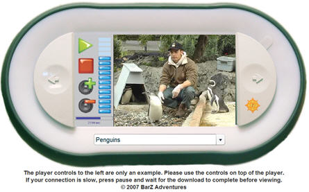
San Francisco Zoo “is pleased to be the first zoo in America to deliver Zoo Ranger tours.”
“Even if you’ve been to the Zoo before, you’ll now see the Zoo from the eyes of the keepers by renting your own personal Zoo Ranger! Zoo Ranger is a hand-held, GPS-triggered device that takes you on an insider’s tour of the Zoo through audio and video. Choose from various options to see how we care for our wonderful animals and learn more about them. You’ll meet many of our individual animals and be touched by their unique personalities and compelling stories. Go virtually “behind-the-scenes” at 25 of our most popular exhibits to experience keeper and animal interactions, witness behavior training, and enjoy animal enrichment sessions. You can even test your wildlife knowledge with the interactive Zoo Trivia feature!”
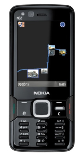
The Nokia N82 is a true travel companion. From the data sheet (PDF):
Photo and Video
5 megapixel camera with Xenon flash, Carl Zeiss optics, autofocus with a dedicated autofocus assist lamp, and MPEG-4 VGA video capture of up to 30 frames per second with video stabilization
High speed camera performance
One-click photo and video uploading from gallery to compatible online albums or blogs with Wi-Fi or 3G
Easy playback of recorded videos and photos on compatible TV using TV out cable or Wi-Fi/UPnP
Geotagging: adds location information to images when they are captured
Navigation
Built-in GPS: Nokia Maps with integrated GPS, Assisted GPS (A-GPS) support
All standard Nokia N82 Black sales packages will come with some local maps preloaded to the memory card
All standard Nokia N82 Black sales packages will have a minimum 3 day free navigation trial
Maps data available for over 150 countries, navigation supported for over 30 countries, 15 million location highlights
This advertisement from Google via YouTube serves as a handsome explanation on what location-based services are and “The new ‘My Location’ (beta) feature on Google Maps for mobile helps you know where you are on the map, even if your phone doesn’t have GPS. Just press [0] to move the map to your approximate location. Save time and tedious keystrokes finding where you are, what’s around you, and how to get there.”
The video is promotion for the Belfast and Titanic Interactive trail, which is offered at Belfast. Produced by Awakin Productions based in Northern Ireland. Awakin’s managing director John Bastard was at mscapeFest07 and told me about this project, in which the Node Explorer is part of the multi-media system:
“Belfast City Council and Northern Ireland Tourist Board have launched the world’s first interactive multi-media digital tourism trail – and, appropriately, it is based around the city’s most famous product, ‘Titanic’.
The ‘Belfast Titanic Trail’ uses the latest GPS-based technology, the Node Explorer, to take visitors ‘back to the future’ – leading them on a tour of the city sites associated with the Titanic story, from the grounds of City Hall to Queen’s Island, finishing by presenting them with a vision of how Titanic Quarter will look.
Using a portable, robust media player, which is both user-friendly and ultra-modern, the Node Explorer – being used for the first time in Belfast – uses a combination of the latest computer technology, still images, video footage, dramatic reconstructions, text and audio clips to take users on a fully interactive trip through time – telling the story of the mighty Titanic and the people associated with her.”
About Awakin: “Awakin is a fast growing provider of Tourism, Heritage & Educational mobile digital content. Awakin was established in April 2004, and was previously part funded by the Northern Ireland Tourist Board to develop new, innovative and exciting digital interpretations in order to promote Northern Ireland as a leading tourist destination.”
About John Bustard, Managing Director: “For the past 3 years John has built up Awakins portfolio to include a range of cutting edge products and brought together a team of highly experienced media producers and directors.“
Yolande Kolstee, she is an officer for Innovation and Quality Care of the Royal Academy of Art (Koninklijke Academie van Beeldende Kunsten, abbreviated KABK), The Hague, Netherlands, and projectleader of the AR+RFID Lab at Royal Academy of Art. She works closely together with
Yolande and Pieter are working with RFID technology already and now are thinking of using the data gloves of their augmented reality systems as another sensor for the mscape system. What their students are doing you can watch in the following two funny videos from the website of AR+RFID Lab via YouTube.
The English website of the AR+RFID lab is: www.kabk.nl/lab
“In the work the listener is asked to locate various substances that form the contemporary urban environment (glass, stone, concrete etc.). As they mark the location of each one they begin to hear interwoven stories connecting them to remote locations around the world, soundtracked with a generative music score. The narratives are progressed and concluded as the listener returns to the locations they chose. The piece is reflective and sometimes melancholy, it touches on issues of climate change and global awareness, but ultimately encourages the listener to treasure the moments around them…”
A video clip from the presentation on the personal navigation system from Dash at the Web 2.0 summit in October 2007 at San Francisco – via Glenn Letham’s AnyGeo Blog:
Suzy Bennett reports on her experience with the iPhone as a travel assistant for a trip to Madrid:
“Before I left for Madrid, I downloaded several guides on to my phone: six podcasts, an audio walking tour, a guide to Madrileño restaurants and bars and a Spanish phrasebook, produced by Rough Guides.
I also “bookmarked” – saved – the Lonely Planet and Rough Guide website addresses, plus a selection of travel blogs for reference.”
There are several observations on the activities of the traditional guidebook publishers like Lonely Planet to cope with the “digital challenge” (e.g. lonelyplanet.tv “a kind of You Tube for travel videos”).


 Posted by Andreas H. Bock
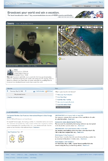


You must be logged in to post a comment.